
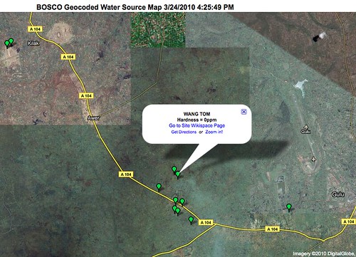
WaterSourceMap, originally uploaded by NDeRC2.
I’ve been out of the country twice since my last post, and have so many items to post that it’s hard to know where to dive back in. The first point I’d like to make here is that you’ve just got to do it, if you’re going to blog. So I’m back.
The map above is a map of water sources in the north of Uganda as posted by students who are part of BOSCO’s classroom-to-classroom (C2C) project. In February I traveled to Uganda for BOSCO, and was really pleased to be able to help set up this mapping project with equipment secured by a fellow teacher, Ms. Robin Dirksen of Lead-Deadwood High School, South Dakota. In Uganda I worked with a number of teachers; Mr. Jokonino Okema of Lacor in the Gulu district, some of his younger teaching colleagues and their students have taken the lead. The idea is that students in Uganda and elsewhere in the world map their water quality data, and learn with and from one another while doing so. Because we have not yet secured a connection with a water/sanitation partner in Northern Uganda, we are beginning (following experience advice) with an innocuous water hardness reading. Students take this reading, the GPS location, images and stories from the location in the field, and then enter this data in a google form embedded in a project wiki page. The map is generated automatically, courtesy of mapalist.com.
I like a lot of things about this project. One of them is that suite of mapping tools–Google forms and spreadsheets, Mapalist, and Wikispaces–are all free, fairly easy for none-too-technical teachers to use (though I did have to look up a few formatting tricks on the mapalist user’s blog), and easily adaptable to almost any mapping task.
This summer we expect to add middle school students from Notre Dame’s Sensing Our World program to this same project.